Ground Penetrating Radar (GPR) is a non-invasive geophysical method used to inspect and map the subsurface. It has become an essential tool in many industries, including civil engineering, construction, archaeology, environmental studies, and even law enforcement. GPR operates by sending high-frequency electromagnetic waves into the ground and analyzing the reflected signals to create images of subsurface features. This method offers a unique advantage: it provides real-time data without the need for excavation, minimizing disruption to the surface while delivering critical information for decision-making.
This article will explain how GPR works, its applications, and the importance of GPR technology solutions in modern infrastructure projects and environmental studies.
What is Ground Penetrating Radar (GPR)?
Ground Penetrating Radar is a geophysical technique that uses radar pulses to image the subsurface. By emitting electromagnetic waves into the ground, the system measures the time it takes for these waves to bounce back after hitting different layers or objects underground. The variations in the returned signals help create a detailed image of the structures or materials beneath the surface.
GPR is capable of detecting a wide range of underground features, including buried utilities, pipes, concrete structures, geological layers, and even archaeological artifacts. It is an incredibly versatile tool because it can be used in various settings, from urban environments to remote, undisturbed locations.
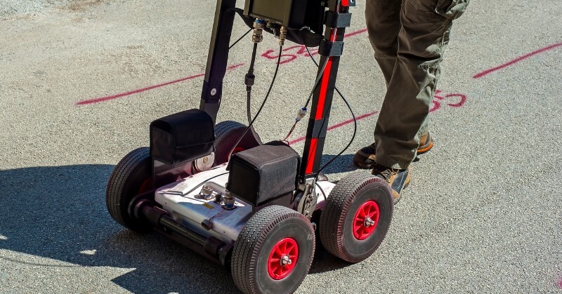
How GPR Works
The fundamental principle behind GPR is similar to that of sonar and radar systems. It uses an electromagnetic pulse to penetrate the ground, and the pulse is reflected back when it encounters materials with different electrical properties. These materials include soil, rock, water, or man-made objects like metal pipes or cables.
The GPR system consists of a transmitter, a receiver, and a computer that processes the data. The transmitter sends out a pulse of electromagnetic energy into the ground, while the receiver detects the reflected signals. The time delay between the emission of the pulse and its return is measured, allowing the system to calculate the depth of different materials.
GPR can be used with various frequencies, depending on the depth and resolution required. Higher frequencies provide better resolution but are limited in the depth they can penetrate, while lower frequencies penetrate deeper but offer lower resolution. The selection of frequency is crucial and typically depends on the type of materials being surveyed and the required depth of investigation.
The data collected by the GPR is processed and displayed in graphical form, allowing operators to interpret the subsurface features. The result is a comprehensive image of the underground structures and materials, which can be analyzed for various purposes.
Why GPR Matters: The Benefits of Ground Penetrating Radar
- Non-Destructive Testing
One of the key advantages of GPR is that it is a non-invasive technique. Unlike traditional methods that involve digging or drilling, GPR allows users to assess the subsurface without disturbing the environment. This is especially valuable in urban settings where excavation may be impractical, costly, or potentially damaging to existing infrastructure. Whether you’re investigating buried pipelines, mapping geological formations, or locating archaeological sites, GPR minimizes the need for disruptive excavation work. - Real-Time Data
GPR provides immediate results, which is essential in many fields where timely decisions are required. For example, in construction projects, engineers can obtain a quick understanding of underground utilities or other obstacles that might affect building foundations. This real-time data reduces delays in projects and helps avoid costly mistakes. - Cost-Effective
GPR is often more cost-effective than traditional excavation methods. Excavating and manually inspecting areas can be time-consuming and expensive, especially in large areas or difficult terrain. GPR technology solutions enable professionals to obtain detailed subsurface data in a fraction of the time, saving both money and resources. - Versatile Applications
GPR technology has a wide range of uses. It can be employed in civil engineering to detect subsurface structures like pipes and cables, in archaeology to locate historical artifacts or buried structures, and in environmental studies to identify contaminants or map groundwater flow. The versatility of GPR makes it an invaluable tool across different industries. - Minimal Environmental Impact
Since GPR does not require excavation, it has minimal environmental impact. It is ideal for use in sensitive areas where excavation could disrupt ecosystems or in locations where traditional digging is not possible due to surface conditions. This makes it a more environmentally friendly option compared to invasive techniques. - Improved Safety
GPR also plays a crucial role in safety. For instance, when mapping underground utilities, GPR helps identify the exact locations of cables and pipes, reducing the risk of accidental damage during construction. Similarly, GPR can be used in disaster recovery operations to locate victims or trapped personnel under rubble without the need for extensive digging.
GPR Technology Solutions: Enhancing Infrastructure Development
GPR technology solutions have transformed how infrastructure projects are planned and executed. Engineers and surveyors can now obtain precise subsurface information before construction begins, ensuring better project planning and reducing the likelihood of unexpected issues.
For example, when building highways, railways, or tunnels, accurate subsurface data is crucial. GPR can help identify rock layers, groundwater levels, and the location of buried utilities that could interfere with construction. This information allows engineers to make informed decisions about foundation design, excavation techniques, and other critical aspects of the project.
Additionally, GPR technology solutions enable the detection of voids or weaknesses in concrete structures, such as bridges or tunnels. This is essential for maintenance and repair, as it helps identify potential structural issues before they become significant problems, ensuring the safety and longevity of infrastructure.
Applications of GPR in Different Fields
- Civil Engineering and Construction
GPR is commonly used to locate underground utilities such as water pipes, gas lines, and electrical cables before construction begins. This prevents accidental damage during digging, saving time and money while ensuring worker safety. Furthermore, GPR is used to assess the integrity of concrete structures, detect cracks, and locate rebar, making it an essential tool for infrastructure maintenance. - Archaeology
GPR has revolutionized archaeological exploration by allowing archaeologists to investigate and map ancient sites without disturbing the ground. This method has helped uncover buried cities, tombs, and other important archaeological features in various parts of the world, providing a deeper understanding of history while preserving the integrity of the sites. - Environmental Studies
In environmental studies, GPR is used to map underground features like contaminated soil, groundwater plumes, and landfills. By identifying the extent and depth of contamination, GPR helps guide remediation efforts and protects the environment. - Forensic Investigations
Law enforcement agencies use GPR to locate bodies, weapons, or other evidence buried underground. This non-invasive technology allows investigators to conduct searches without disturbing the surrounding area, which is especially valuable in criminal investigations.
Conclusion
Ground Penetrating Radar is a powerful tool that offers a wealth of benefits across many industries. Its ability to provide real-time, non-invasive, and accurate subsurface data makes it an invaluable resource for civil engineering, archaeology, environmental science, and more. With advancements in GPR technology solutions, professionals now have access to more sophisticated tools that improve the efficiency and safety of their projects. Whether detecting buried utilities or mapping historical sites, GPR continues to change the way we explore and interact with the underground world.